
Sunday, December 17, 2006
Friday, December 01, 2006
It's Over!
TALLAHASSEE (AP) — A quiet hurricane season ended on Thursday and it looks as though the final totals will be nine named storms and five hurricanes.
All of the hurricanes spun to the east of the United States except Ernesto, which sputtered into a tropical storm before it landed in South Florida.
Two tropical storms hit Florida this year - the other was Alberto, which made landfall in the Big Bend in June.
What a difference a year makes. Last year there were a record 27 named storms and 15 hurricanes, four of which reached Category 5 strength.
This year's hurricane season never came close to the predictions.
Experts say the quiet season was due to a prevailing high pressure system that shifted to the east and helped steer storms away from the U-S.
But Florida Emergency Management Director Craig Fugate says we are still in an active cycle of hurricane activity that could last another twenty years.
Tuesday, October 03, 2006
Saturday, September 30, 2006
Fortunately, I haven't had much to say in September!
Besides being out of town more than in during, September, Gordon, Helene, & Issac all followed one another up into the North Atlantic leaving me with nothing to say here. Hopefully I won't be posting much in October either!
In the meantime, take 1 minute to look at this EXCELLENT animation of the amount of damage various hurricane categories can have on property. Click here.
In the meantime, take 1 minute to look at this EXCELLENT animation of the amount of damage various hurricane categories can have on property. Click here.
Wednesday, September 13, 2006
Zero 2 Eight
Tuesday, September 12, 2006
Gordon Forms, Follows Florence....
Headed into the North Atlantic. We're nearly 1/2 way through the peak month of the season.
Sunday, September 10, 2006
Light Earthquake Season? How about an Earthquake?
ATLANTA, Georgia (CNN) -- A strong, 6.0 earthquake in the Gulf of Mexico was felt throughout the Southeast but caused no apparent damage, according to the U.S. Geological Survey.
The quake was not powerful enough to trigger a tsunami warning.
The quake, about 250 miles west of Tampa, Florida, was "pretty unusual" for the area.Florence continues to strengthen and is now a Cat 1 Hurricane that will impact Bermuda on Monday. Here's the AP Story.
Saturday, September 09, 2006
The Alberto and Ernesto Show
The Roanoke Times take on this year's rather tame hurricane season. Meanwhile Florence will affect Bermuda before disappearing in the North Atlantic.
Wednesday, September 06, 2006
Turn Baby Turn!
All models show Florence growing big but turning up and away from the "lower 48". But hold on to your Bermuda shorts if you're on that island.
Tuesday, September 05, 2006
Florence is out there....

From the Associated Press: Tropical Storm Florence formed far out in the open Atlantic on Tuesday, and forecasters said it will probably become a hurricane.
But they said it was too soon to tell whether the sixth named storm of the hurricane season would reach the United States.
Florence had sustained wind near 45 mph, 6 mph over the threshold for a tropical storm. The minimum for a hurricane is 74 mph.
"Our forecast does have it becoming a hurricane by Friday morning - minimal hurricane, Category 1," National Hurricane Center meteorologist Mark Willis said.
At 5 p.m. EDT, the storm was centered 960 miles east of the Lesser Antilles, or about 2,100 miles southeast of Miami, and was moving northwest at about 12 mph.
The storm follows on the heels of Tropical Storm Ernesto, which was briefly the season's first hurricane before weakening and hitting Florida and North Carolina last week as a tropical storm. It formed over the southern Caribbean on Aug. 25.
At least nine deaths in the United States were blamed on Ernesto, which also killed two people in Haiti, delayed the launch of the space shuttle Atlantis and blacked out thousands of homes and businesses from North Carolina to New York state.
Last year's Atlantic storm season had a record 28 named storms and 15 hurricanes, including Katrina.
Monday, September 04, 2006
Still a Depression ......but.....
Accuweather at 11:50am this morning said "It is not out of the question that it could be a major hurricane at that time. One other feature associated with this tropical wave is a front-running area of low pressure between 45 and 50 west. This feature should stay on a more westerly course toward the Lesser Antilles. It could end up as a developing tropical cyclone across the northwest Caribbean or close to South Florida next weekend. "
Sunday, September 03, 2006
Tropical Depression 6 forms in Atlantic
1525 miles east of the northern Leeward Islands. Accuweather thinks it could become Tropical Storm Florence on Labor Day and then track west to be north of the Virgin Islands or near South Florida by next weekend.
Friday, September 01, 2006
2006 Hurricane Forecast Lowered!
Hurricane authority Dr. Wiliam Gray wrote today: "We now anticipate that the 2006 Atlantic basin tropical cyclone (TC) season will be considerably less active than the seasonal activity we anticipated in our earlier forecasts and in our updated 3 August forecast.
We now expect that the 2006 hurricane season will have slightly less hurricane activity than the long-term average. This is due to an unexpected increase in tropical Atlantic mid-level dryness (with large amounts of African dust) and a continued trend towards El Niño-like conditions in the eastern and central Pacific"
September is typically the busiest month and he's calling for 5 named storms, 3 hurricanes, 2 major hurricanes.
No sign of Florence yet.
Wednesday, August 30, 2006
Ernesto Injured! Florence Conceived?
 Thank you Haiti and Cuba for breaking Ernesto down to a very weak tropical storm. Winds are minimal and should be just a big rainmaker in Florida and primarily along the East Coast. The Carolinas will get rain and the possibility of some reformation so we wish them the best.
Tampa Bay will just see a very rainy day and a good dry run. Many stocked up on their hurricane supplies and reviewed their own personal storm plans
Meanwhile September may prove to be a very busy month starting with a tropical wave out in the Atlantic that forecasters expect to become a depression and eventually a named storm - Florence.
Something to look forward to next weekend!
Monday, August 28, 2006
Ernesto Roundup
We're feeling better here in the Tampa Bay area as the "cone of uncertainty" becomes some other community's bigger concern. All day today we've slowly edged towards the western fringe of the cone giving us reason to offer a collective sigh of relief. The forecasted path now seems to be more towards the eastern side of the state.
But things could change so we won't take our eye of the bouncing ball.
Sunday, August 27, 2006
Eastbound and Down.....but not Out!
 In the course of the day, the bullseye has gone from the first "R" in Clearwater to the last "R" (Click on map to enlarge).
The entire state is in the "Cone of Uncertainty" but the predicted path does appear to be shifting to the East. Possibility that the storm may try to go straight up the middle of the state.
As of 11pm, the land mass of Hispanioia (Haiti) has helped Ernesto to be downgraded to a Tropical Storm, but it's expected to strengthen overnight as it gets back out into the open warm waters of the Carribean.
We'll see what tomorrow brings....
Guess where we live?
 See the letter"R", that's hidden by the projected path in the word Clearwater on this map? (Click on the map to enlarge)
That's us!
Now, while I'm now concerned and making initial preparations for possible landfall on Thursday, the good news in my mind, is that I'd rather be in the bullseye today, rather than in 5 days.
We'll be watching updates carefully!
Saturday, August 26, 2006
Max Mayfield Calling it Quits!
"I'm tired," he said Friday.
Meanwhile, Ernesto will keep us watching the Gulf heading into Labor Day!
Thursday, August 24, 2006
It's getting Busy....
Debby - No Threat!
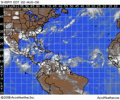
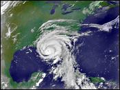
Ernesto - Probably will be named within next 24 hours - Currently Tropical Depression #5.
TD #5 satellite image
One Year ago today, Tropical Storm Katrina formed in the Bahamas. Accuweather has a real good series which chronicles the historic and catastrophic event - "Katrina: One Year Later"
14 years ago today, Hurricane Andrew struck South Florida. Here's the recap of that disaster.
NASA Developing Hurricane Drone
A demonstration flight of the unmanned Aerosonde Hurricane Boundary Layer Aerial System is scheduled today at the Naval Air Facility in Key West, Fla.
Meanwhile, most forecasts have Debby headed up in to the Atlantic and threatening no one except the sea life and transatlantic ships.
Meanwhile, most forecasts have Debby headed up in to the Atlantic and threatening no one except the sea life and transatlantic ships.
Tuesday, August 22, 2006
Is Debby coming?
From the New York Times:
"Almost halfway through a hurricane season that had been predicted to be particularly awesome, the fourth potential hurricane of the year is gathering strength off the coast of West Africa, the National Hurricane Center said this morning. The three previous storms all fizzled out harmlessly at sea without reaching hurricane strength."
The Tropical Storm is named Debby and formed this evening. Could be in Bermuda in a week, could just turn north into the Atlantic and not bother anyone.
Stay tuned.
Saturday, August 12, 2006
My Hurricane Wind Insurance Premium Has Tripled!
My wind insurance was transfered from the company, Citizens, which was called the "insurance of last resort" to another company which I imagine is the "insurance of TRULY last resort". Oh and by the way, it now costs THREE times what it did last year.
And that's just the wind portion.
I still have normal homeowners and flood, which gratefully did not go up more than a normal year over year increase. Most homeowners have hurricane insurance, albeit, paying through the nose. A fair number of commercial businesses had their insurance cancelled completely, hence, a special session of the Florida legislature may be called to deal with the issue
Wednesday, August 09, 2006
2006 Hurricane Forecast Lowered
....but really we're just getting started. Next Depression may be forming near the Lesser Antilles over next day or two. Lots of wind and rain but no formation at this point per Air Force Reconnaissance.
Everyone is calm here in Florida at the moment focused on gas prices, insurance rates, and summer heat.
Everyone is calm here in Florida at the moment focused on gas prices, insurance rates, and summer heat.
Monday, August 07, 2006
Thursday, August 03, 2006
TS Chris Weakens!
But could re-form so we'll keep an eye on the news. CNN's headline is "Chris Falls Apart", however that may be a bit overstated.
Meanwhile, quite the thunderstorm in Chicago last night. If the rains ends today, it's an Ernie Banks kind of day and we're playing two at Wrigley!
Meanwhile, quite the thunderstorm in Chicago last night. If the rains ends today, it's an Ernie Banks kind of day and we're playing two at Wrigley!
Wednesday, August 02, 2006
Still watching Chris from Chicago.....
Tuesday, August 01, 2006
It's August, so let's start getting serious again!

It was 2 years ago August that I started this blog in the form of emails to some of you. Charlie was threatening Florida and I was stuck at an airport in New England, at the end of a vacation, hoping my flight would leave and trying to get the latest weather on my cellphone's Internet browser.
Since then the term "Hurricane" is much more on the tips of all Americans' tongues especially starting in August and especially in Florida and the Southeast. That's when the conditions in the Atlantic and Gulf of Mexico begin to be much more favorable for the development of storms. The warm water conditions will continue right through the end of the season in late November when they finally begin to cool down.
It's no surprise that I wake up (on vacation again in Chicago - where the heat this week is worse than anything we experience in Florida) to hear about "Chris", the 3rd named storm of the 2006 season, which may become an issue in the US early next week.
For the details from my favorite source of excellent Hurricane forecast information, click here.
Monday, July 24, 2006
This time last year we were watching Storm Number 6

Showers in Gulf bear watching....
MIAMI - Hurricane forecasters this morning are pointing to an area of showers in the southwestern Gulf of Mexico as the only storm concern through Tuesday.
The disorganized showers could develop into a tropical disturbance in the next few days as the showers track to the north and northwest, the National Weather Service said in a 5:30 a.m. advisory. The showers were not a threat to Florida.
"Elsewhere, tropical storm formation is not expected through Tuesday," said the Miami center, which watches the gulf, the Caribbean Sea and the North Atlantic Ocean.
Tuesday, July 18, 2006
Beryl forms off the Coast of the Carolinas
This is the fifth Beryl since coming into the storm rotation in 1982.
The storm was upgraded from a tropical depression Tuesday afternoon.
At 5 p.m. ET Tuesday, the storm was centered about 180 miles (290 kilometers) southeast of Cape Hatteras and was moving toward the north at nearly 6 mph (9 kph), the National Hurricane Center said. A slow turn toward the north-northwest was expected later Tuesday or Wednesday.
....but things can change quickly!
Activity is picking up in the Atlantic Ocean today as conditions become more favorable for tropical storms to develop.
The National Hurricane Center is watching three low pressure systems -- one of them off the North Carolina could build quickly.
"Although the low is currently not well-organized, there is a potential for a tropical depression to form during the next day or two," hurricane center forecasters said in a statement today.
A hurricane hunter aircraft is scheduled to investigate the area later today.
Friday, July 14, 2006
No tropical storm formation forseen....
.....for the waters touching Florida for several days, the National Hurricane Center said today (Friday July 14, 2006).
In its daily, 5:30 a.m. advisory, storm watchers in Miami said a tropical wave, which they had been watching all week move from the North Atlantic into the Caribbean Sea, has weakened.
"The U.S. now is a month and a half into its 2006 hurricane season, and so far there has been one named tropical storm."
Monday, July 10, 2006
One Year Ago - Hurricane Dennis Struck Florida
On this date last year, Hurricane Dennis struck Florida.
Dennis was the earliest forming category 4 storm in the Caribbean. The hurricane, which weakened to a category 3 before it made landfall with 120 mile-an-hour winds near Navarre Beach in the Panhandle, spawned 10 tornadoes.
Meanwhile, tropical waves continue to form in the Eastern Carribean only to be knocked down by upper level wind shear. Accuweather is saying that the shear is beginning to disapate and surface pressures are lowering which could allow this and future waves to better organize. We'll be watching!
Thursday, June 22, 2006

Friday, June 16, 2006
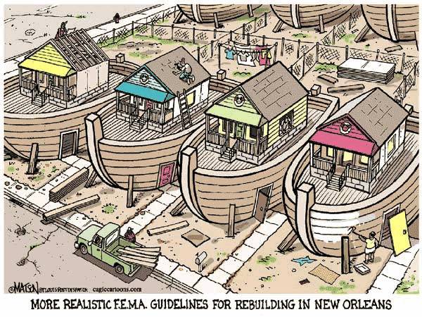
Hooters Wants To Pay FEMA For Champagne Bought With Hurricane Credit Card

The Hooters restaurant chain is looking for FEMA's address.
Company Chairman Bob Brooks says he wants to reimburse the agency for the 200-dollar bottle of Dom Perignon Champagne that was purchased with a government credit card issued to Hurricane Katrina victims.
The champagne was purchased in San Antonio. It was among numerous examples of improper spending of hurricane relief money cited earlier this week by Congress' Government Accountability Office.
The GAO says the bogus spending could be as high as one-point-four (b) billion dollars. "
Tuesday, June 13, 2006
Missed Us!
The first tropical storm of the hurricane season was less than advertised.
Here's the St. Petersburg Times summary
Here's the St. Petersburg Times summary
Monday, June 12, 2006
Is it a bad sign when the network storm chasers show up in your town?
Ahead of T.S. Alberto, The Weather Channel was reporting live from our little community of Safety Harbor Sunday and tonight, NBC/MSNBC is in the exact same spot
We sit on the western edge of old Tampa Bay, which is at about 10 o'clock as you look northward at a map and see the big body of water in the middle of the Tampa-St. Petersburg DMA.
Safety Harbor is best known for its world-known Spa which attracts visitors from around the world but mostly the US Northeast.
We're about 12 miles from the Gulf of Mexico which is the direction this Storm is pushing rain and wind in from. We do, however, run the risk of a storm surge coming up Tampa Bay and pushing water into the Safety Harbor community. Our house is about 1 mile from the Bay but not in a flood zone. We also have a noticeble creek bed between us and the Bay that would absorb some surge should it make it that far.
Right now we're getting some well needed rain and occasional gusts of wind no worse than any we've seen over the past two storm seasons. The latest forecast seems to indicate we should miss the worst of it but do have the threat of tornados and flooding through tomorrow afternoon.
Sunday, June 11, 2006
Wednesday, June 07, 2006
Hurricane phone available for $4,995
The kit, launched last month by Assemble Communications LLC of Davidson, N.C., comes in a watertight suitcase and features a battery-powered Inmarsat satellite antenna and handset. It also comes with cables to connect a computer to Inmarsat's broadband Internet service.
The price includes 400 minutes of talk time that don't expire until used and 150 megabytes of Internet access - enough for about two days of average surfing.
Entire Story
The price includes 400 minutes of talk time that don't expire until used and 150 megabytes of Internet access - enough for about two days of average surfing.
Entire Story
Saturday, June 03, 2006
Ok....We're all set

BUT, others are not...
Florida officials worry about 'hurricane fatigue': A Mason-Dixon poll found that 83 percent of coastal residents still haven't fortified their homes, 68 percent haven't assembled a survival kit, including a first-aid kit, food, water, medicines, flashlights, a radio and batteries, and 60 percent have no family plan."
Thursday, June 01, 2006
The season starts today....only 183 days to go.....
U.S. East Coast Has Greatest Odds of Hurricane Strike.... A 69 percent chance this season of being hit by a Category 3 hurricane.
Monday, May 29, 2006
2006 Hurricane Season may not be as bad as last 2?
Phil Klotzbach and William Gray, two of the nation's leading hurricane forecasters, wrote in December, "Even though we expect to see the current active period of Atlantic major hurricane activity to continue for another 15 to 20 years, it is statistically unlikely that the coming 2006 and 2007 hurricane seasons, or the seasons which follow, will have the number of major hurricane landfalls as we have seen in 2004-2005."
We can only hope!
We can only hope!
Saturday, May 27, 2006
And so it begins....in the Pacific
Sunday, May 21, 2006
Countdown to Hurricane Season 2006
10 days and counting. Meanwhile, here in Florida, the sales tax holiday begins today to for residents to prep for the coming season.
Congratulations and best of luck to Mayor Nagen!

Congratulations and best of luck to Mayor Nagen!
Saturday, April 15, 2006
Meanwhile...The Annual 28th Annual National Hurricane Conference concluded Friday
Lots of nuggets of news to choose from....
28th storm added to 2005 Tally
On 4/12/06, a 28th tropical storm was added to the 2005 Hurricane Season. An unnamed subtropical storm that formed October 4th near the Azores Islands, which then disapated the next day, is now included in the record-setting 2005 hurricane season.
Friday, February 03, 2006

Subscribe to:
Posts (Atom)