The Hurricane Center has only issued 21 names!
Click here to see the List
WILMA!!!
Tuesday, July 26, 2005
Sunday, July 24, 2005
Who would have thought 7 named storms before the end of July?
Tropical Depression Seven becomes Tropical Storm Gert in the Bay of Campeche Sunday morning and Tropical Storm Franklin is Moving Toward Bermuda
Gert will affect the eastern Mexican coast near Tampico Sunday evening.
Time to listen to Jimmy Buffett's Changes in Lattitudes -- Changes in Attitudes CD with the track "Tampico Trauma"
Gert will affect the eastern Mexican coast near Tampico Sunday evening.
Time to listen to Jimmy Buffett's Changes in Lattitudes -- Changes in Attitudes CD with the track "Tampico Trauma"
Saturday, July 23, 2005
Which "expert" has been right so far this season?

Joe Bastardi of Accuweather predicted the "Central Gulf Coast" would be the hot spot this season.
Read the article
Read Joe's bio
Friday, July 22, 2005
Storm # 6 is born! Franklin is his name
Click on the headline above for the tracking map.
Looks like from the Bahamas he's going on an Atlantic Ocean cruise.
We certainly hope so!
Looks like from the Bahamas he's going on an Atlantic Ocean cruise.
We certainly hope so!
Saturday, July 16, 2005
Friday, July 15, 2005
Emily a Category 4 Yet Again
Strengthening, weakening, and strengthening again; Emily is once again a Category 4 hurricane.
Thursday, July 14, 2005
EMILY Becomes a DANGEROUS category 3 Hurricane!
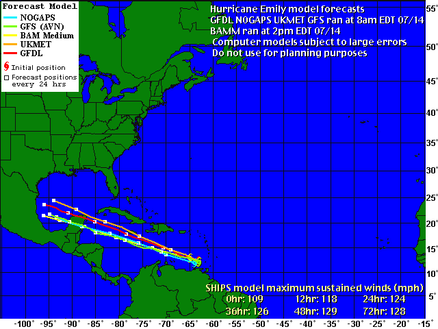
AT 5 PM AST...2100Z...THE GOVERNMENT OF JAMAICA HAS ISSUED A
HURRICANE WATCH FOR JAMAICA.
Could be a Category 4 by the time it reaches Jamaica!
State of Florida appears to be out of play on this one, but keep your eye on the west coast of Africa where these things are incubating!
Wednesday, July 13, 2005
Emily is Now a Hurricane!
Looks like she'll stay south of the Florida Pennisula. Mexico and South Texas appear to be in the projected path's "cone of uncertainty".
Meanwhile.... Do you know where do the Alligators go during a storm?
Meanwhile.... Do you know where do the Alligators go during a storm?
Sunday, July 10, 2005
The next one may already be brewing...
From Accuweather Sunday Night:
"What could very well become the season's next tropical cyclone is in the Atlantic with a developing cloud mass at 11 north and 40 west. With water warm and shear low, next week at this time yet another tropical threat may face the coastal United States. "
Could it be deja vu all over again!
Sun came out Sunday afternoon. All clear here. Best to those in the southeast still being affected by Dennis!!
Rain & Wind just about done here....
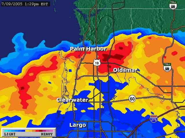
 The storm pounds into the panhandle and lucky for us we just have a few leaves down in our front yard (We are located where the green on this radar shot is ending on the west side of the state).
Some minor street flooding in the low lying spots in the Tampa Bay area due to high tide and storm surge this morning but we were unaffected.
Saturday, July 09, 2005

Dennis Sideswipe!
Fairly calm since the last post. Occasional gusts but nothing like last season. Looks like the tropical storm force winds didn't quite make it this far from the storm center
Actually went out and ran some errands. You can see we still have a lot of rain over the area and the back side of the storm tonight and tomorrow. Best of luck to the Florida Panhandle and southern Alabama, Mississippi & Louisian!
Some Strong Weather Moving Through our Area Right Now
Small tornado hit one beach area south of us this morning. At this moment a strong band of weather is passing over us. Tornado Warning in effect until 2pm EST for our county. Heavy rain and wind visible from our house.
2800 people in our county without power currently.
We're okay but expect more fast moving heavy bands of weather through tomorrow.
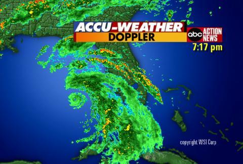
Click here to see the size of Dennis!
7am Saturday - Dennis's outer bands of rain and wind begin!
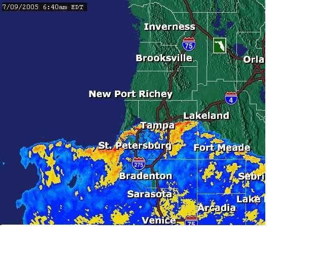
A rainy day in Tampa Bay!
As I post this the rain has just begun. The storm will pass to our west. When it gets to 27.96 lattitude, we are in the clear for an unexpected and unlikely sudden right turn. Currently it's at 23.9.
Meanwhile, I think we'll stay inside today!
Thursday, July 07, 2005
Now I'm getting ANGRY!

Tropical Storm Cindy created tornados have caused an estimated $10-40 million worth of damage to our favorite NASCAR race track, Atlanta Motor Speedway .
The General Manager is an old friend of ours and I sure feel sorry for what he found this morning.
Meanwhile, we're not sure where Dennis is headed. The "cone of uncertainty" keeps wobbling to include or exclude our area. We'll know more late Friday after the storm passes Cuba. We'll gas up the vehicles tomorrow and prepare for at best a rainy somewhat windy weekend. At worst.....
He's headed to the Gulf of Mexico

The west coast of Florida is slowly moving to the outer edge of the "cone of uncertainty" as Dennis' future path computer models point towards the Florida panhandle.
The last named Hurricane this early in the season was Bertha in July 1996 that hit the Wilmington, NC area. 5000 homes were damaaged at a damage cost estimated at $270 million. Bertha was responsible for eight deaths.
Wednesday, July 06, 2005
Just a signal of what's to come......or getting them out of the way early?
Recorded Hurricane history goes back to 1851 and this is the earliest 4 named storms have developed this early in the season!
Overheard yesterday: "4 Down 11 to go! Maybe we're just getting them out of the way early this year"
Also overheard: "We had 4 storms hit the state last year. They're still coming in fours"
Overheard yesterday: "4 Down 11 to go! Maybe we're just getting them out of the way early this year"
Also overheard: "We had 4 storms hit the state last year. They're still coming in fours"
Tuesday, July 05, 2005
2 Hurricanes Happening This Week!
As of 11 a.m. today, Tropical Storm Cindy is moving toward the north at 14 mph and a gradual turn toward the north-northeast is expected during the next 24 hours. On this track, the center will be nearing the North Central Gulf Coast tonight or early Wednesday. Maximum sustained winds are near 50 mph. A Tropical Storm warning is now in effect from Intercoastal City, La. eastward to Destin, Fla.
Tropical Storm Dennis is centered about 355 miles south of San Juan, Puerto Rico and is moving west-northwest at 18 mph. It has top sustained winds of 40 mph and is on track to reach Haiti on Wednesday.
We're much more interested in Dennis which is currently projected to sweep up the eastern end of the Gulf of Mexico perhaps affecting us along Florida's West Coast!
Humor to follow!
Subscribe to:
Posts (Atom)