
It’s been another Tropical Storm season where nothing has happened during the first half (Peak season is September 10th), so we’re all complacent.
While were watching Hillary on the west coast, we have a sneak attack developing on our backside…..
Stay tuned….

She has a big wind field, but is moving fast and for Tampa Bay, should just be a wind and rain event through mid-day today and then, like Ian, cool weather comes in behind.
For most, it's just another work day with a fair amount of traffic on the roads while schools are closed and probably most events this morning postponed or delayed.

Well once again the Tampa Bay area avoided the worst of a Hurricane. We are sorry for those in Southwest Florida (Ft. Meyers area) who took the brunt of Ian.
The Tampa Bay area had alot of tree debris and minor damages but NOTHING compared to down South.
Our community had the tree debris picked up by the next day and did another sweep for those who needed more than 24 hours to clean up their properties. There are still some debris piles more towards the eastern Tampa side of the bay.
Lot's of talk and thank yous to the Tocobaga Tribe:
For centuries beginning in 900, the Tocobaga tribe inhabited the coastline of Tampa Bay, surviving on a diet consistingmostly of fish and shellfish. The tribe began dying off due to war and disease brought by a Spanish explorer and his men in the 16th century. Althought the timeline is somewhat unclear, the tribe had been completely wiped out some time before 1800.
These are the storm tracks since just 1960. The last major hurricane to directly hit Tampa Bay was in 1921. Large burial mounds remaining from the Tocobaga civilzation are still present today with the oldest one about a mile from where we live overlooking Old Tampa Bay in the area known as "Safety Harbor".
Many people think the mounds could be providing supernatureal protection from hurricanes.
Of course, some think the MacDill Air Force Base in Tampa has some type of radar, sonar, lidor device that keeps the storms away since they are the base for Central and Southern Command.

Some interesting notes:
The similar paths of Charlie in 2004 and Ian in 2022:


For those friends elsewhere asking or wondering about how & what we’re doing:
Excellent piece on betting odds for the rest of the 2022 Hurricane Storm Season (and why):

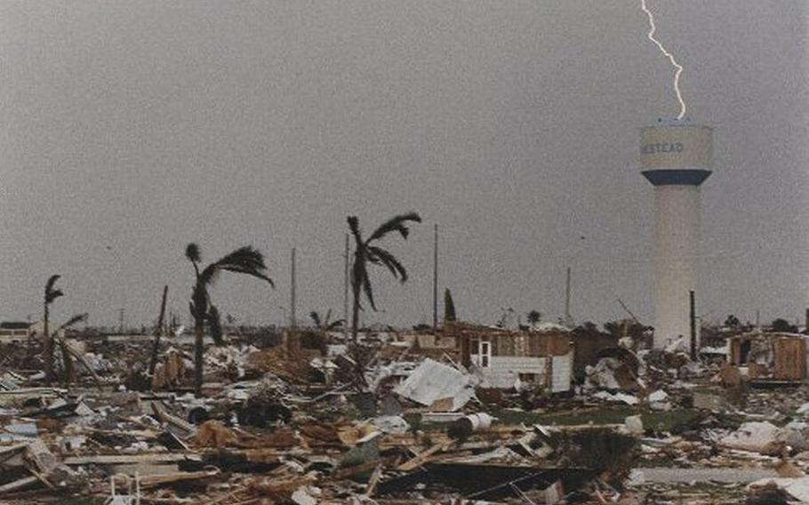
30 years ago Hurricane Andrew came ashore in South Florida.
You can read all about here
We were living in Charlotte at the time which was recovering from Hugo. A year later we moved back to Southwestern Florida and watched across the state for the next 10 years (and more) as Homestead recovered.
We were fortunate to miss both.
My biggest takeway is not to be fooled by a quiet season. As the first named storm of the season, it was late August before Andrew hit. And while 1992 was a below average season, there were 7 named storms, 4 hurricanes and, the catastrophic Andrew
And, so many new requirements for future storm preparedness became Florida law in the aftermath.
Today, we have been very quiet but things are heating up.....

