
Tuesday, October 11, 2016
Why Did Matthew Wobble?
Excellent recap from The Weather Channel & some awesome pictures from throughout Matthew's path: https://weather.com/storms/hurricane/news/hurricane-matthew-florida-could-have-been-worse
Reported Matthew Impact on Tampa Bay So Far....
According to the Tampa Bay Business Journal, there have been 80 regional insurance claims thus far, the most of which were in Sarasota County. Here's the article.


Sunday, October 09, 2016
Matthew Aftermath
There is plenty of coverage of Matthew on the Internet. Unlike when I started this blog 12 years ago, it's easy to access the news, both in terms of live video & blog feeds from those inside the path via Twitter, Facebook and other social media, not to mention a simple Google search. Back in the day I might have included links to coverage I had found on the web, but it really seems necessary today.

In 2004 when Charley, Jeanne & the others hit, 64 in 100 people had cellphones. Today 112 in 100 have one, most of which are smart phones with cameras and easy connection to connect to the Internet to share their experiences.
In summation from the West Coast of Florida, where we had nothing more than a little rain and some slightly-more-than-normal wind, we have nothing to complain about and feel lucky we aren't going through what our fellow Floridians (as well as Carolinians) are going to have to go through to clean up and restore.

My only concern going forward is that since the majority of the residents here in Florida were NOT affected (or very slightly affected) and the coverage during the impact of the storm "seemed" alot less than expected (where were those 9 foot storm surges in Florida?), that we will continue to be complacent should another storm take a more powerful head-on impact into the state.
I give the governors of each state affected a lot of credit for taking the most serious warning approach to their messaging, even if it seems that the impact was not has bad as advertised. Another 30-50 miles closer to shore or a left turn to make a Florida landfall, and perhaps it would have been as bad or worse than warned.
And of course, thank you the first responders and condolences to anyone who lost life or significant property!

In 2004 when Charley, Jeanne & the others hit, 64 in 100 people had cellphones. Today 112 in 100 have one, most of which are smart phones with cameras and easy connection to connect to the Internet to share their experiences.
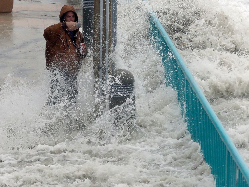
Brian Johns is hit by a wave as he tries to video the effects of Hurricane Matthew, Oct. 7, 2016, in Daytona Beach, Fla.

My only concern going forward is that since the majority of the residents here in Florida were NOT affected (or very slightly affected) and the coverage during the impact of the storm "seemed" alot less than expected (where were those 9 foot storm surges in Florida?), that we will continue to be complacent should another storm take a more powerful head-on impact into the state.
I give the governors of each state affected a lot of credit for taking the most serious warning approach to their messaging, even if it seems that the impact was not has bad as advertised. Another 30-50 miles closer to shore or a left turn to make a Florida landfall, and perhaps it would have been as bad or worse than warned.
And of course, thank you the first responders and condolences to anyone who lost life or significant property!
Friday, October 07, 2016

West Coast of Florida OK
So far we really haven't experienced anything more than a few minor wind gusts. Since we are 10 miles from the Gulf of Mexico, we're pretty insulated from Matthew which of course is a terrible concern for the east coast of Florida.
We spent most of yesterday watching The Weather Channel, CNN & Twitter to follow Matthew's north/northwestern approach to the peninsula.
Here's what radar looked like last night, but the rain was so light we only received less than a quarter of an inch overnight.

We spent most of yesterday watching The Weather Channel, CNN & Twitter to follow Matthew's north/northwestern approach to the peninsula.
Here's what radar looked like last night, but the rain was so light we only received less than a quarter of an inch overnight.

Wednesday, October 05, 2016
Matthew Already A Record Setter
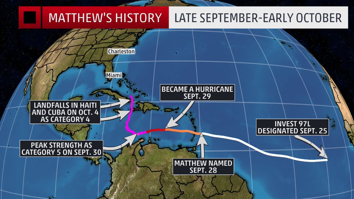
Hurricane Matthew has already set records:
- The longest-lived Category 4-5 hurricane in the eastern Caribbean on record
- A Category 4-5 hurricane for 102 hours, which is the longest that a hurricane has maintained Category 4-5 strength on record during October in the Atlantic basin.
- The longest-lived major hurricane since Hurricane Ivan (2004).
- Generated the most ACE (accumulated cyclone energy <length+intensity>) of any hurricane in the eastern Caribbean on record
- No hurricanes on record have made landfall north of Miami along the east coast of Florida in October and no major hurricanes have made landfall since Wilma in 2005. Each of these records has the potential to be broken in the next few days.
West Coast of Florida Safe from Matthew?
Here in the Tampa Bay area, we've been watching the foretasted track of Hurricane Matthew more intently over the weekend and into this week. At first it appeared that the entire peninsula would be spared but as the cone of uncertainty has shifted more westward and the storm continues to intensify, we've paid even more attention.
That said, we seem to be in a better position to only receive some additional rain and wind but nothing that should be damaging. On the west side of the storm potentially even could suck some of the moisture out of the air according to local meteorologists.


We feel bad for Haiti and what the Bahamas may endure today and are concerned about the impact to coastal Carolina later in the week.
I continue to have the Weather Channel on and keep an eye on some of the weather Tweeps I follow.
Monday, October 03, 2016
Florida's Back In Play
Interesting to note that 7 of 9 major hurricanes making U.S. landfall in October since 1900, have done so in Florida.

Saturday, October 01, 2016
Matthew is intense!
Here in Florida we are watching Hurricane Matthew even more intently. Matthew just about doubled its wind-speed in 24 hours. It intensified by 80mph. Only Wilma in 2004 & Felix in 2007 had stronger 24 hour intensification per Philip Klotzbach The east coast of Florida is still in the cone of uncertainty and this storm is currently Category 4 (had been a "5" briefly overnight), the strongest since Felix!

Subscribe to:
Posts (Atom)