Thursday, December 01, 2016

The Season & the Drought Are Over

While I had more to watch & post about this summer and even had some minor impact from this season's storms, but all-in-all, it was much to do about nothing on the West coast of Florida.  Yes, we had a lot of rainfall that impacted some low lying areas around Tampa Bay.  But, these areas tend to flood on any heavy rain.   I'm sorry for those impacted by that, but they are used to it and I don't believe there was much serious damage to many homes or property

Yes, the headline is that after 10 years (Wilma in 2005), we finally had a hurricane make landfall in the state of Florida (Hermine)

We sat through a full day of rain from Hermine on September 2nd in Darlington South Carolina after it passed by the Tampa Bay area and made landfall in the Big Bend area of Florida and continued Northeast.  At home we received well over 5 inches of rain that day.


Matthew didn't throw anything but some lighter rain at us over here, which was the last significant rain we received the week of October 3rd.   While no wildfires (like in the Carolinas and Tennessee), we haven't seen rain in nearly 2 months here in Tampa Bay.

Here's one recap of the 2016 season:   http://www.miamiherald.com/news/weather/hurricane/article117789853.html

Tuesday, October 11, 2016

Sunday, October 09, 2016

Matthew Aftermath

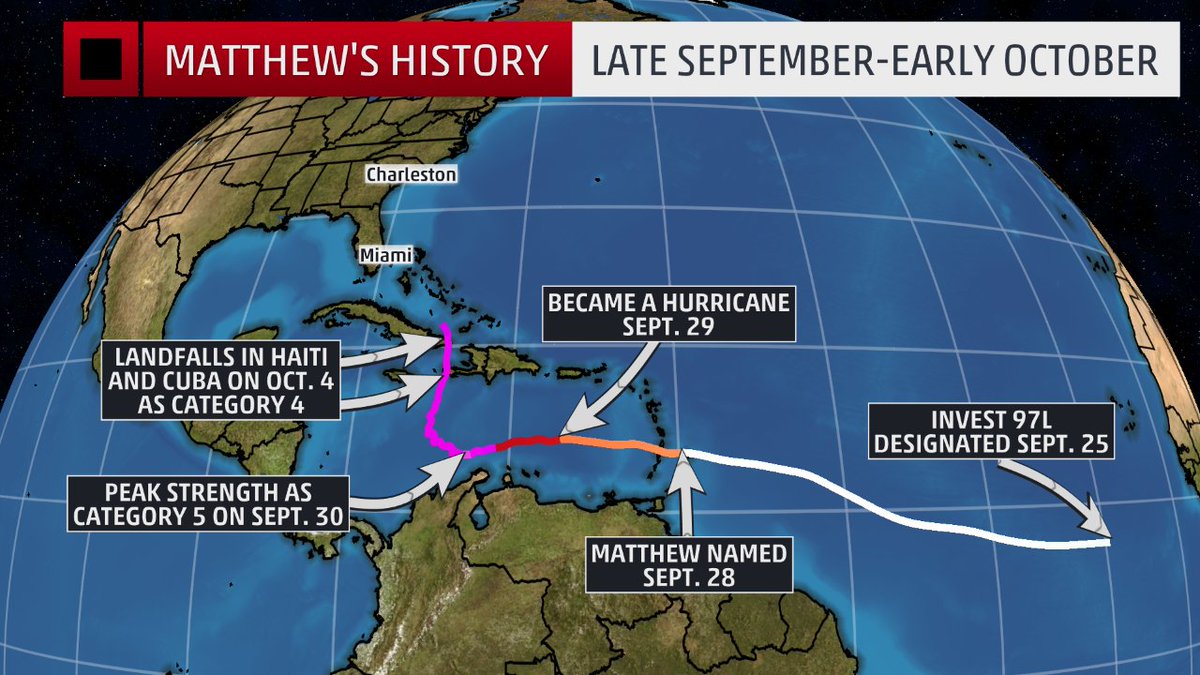
There is plenty of coverage of Matthew on the Internet.  Unlike when I started this blog 12 years ago, it's easy to access the news, both in terms of live video & blog feeds from those inside the path via Twitter, Facebook and other social media, not to mention a simple Google search.   Back in the day I might have included links to coverage I had found on the web, but it really seems necessary today.


In 2004 when Charley, Jeanne & the others hit, 64 in 100 people had cellphones.   Today 112 in 100 have one, most of which are smart phones with cameras and easy connection to connect to the Internet to share their experiences.


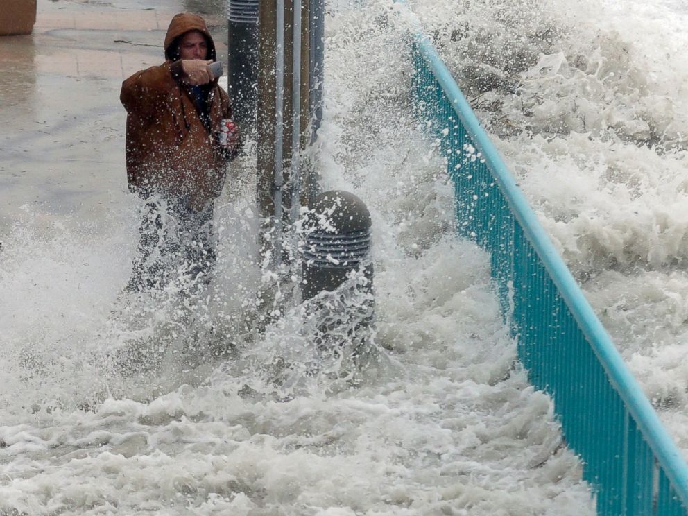
Brian Johns is hit by a wave as he tries to video the effects of Hurricane Matthew, Oct. 7, 2016, in Daytona Beach, Fla.


In summation from the West Coast of Florida, where we had nothing more than a little rain and some slightly-more-than-normal wind, we have nothing to complain about and feel lucky we aren't going through what our fellow Floridians (as well as Carolinians) are going to have to go through to clean up and restore.


My only concern going forward is that since the majority of the residents here in Florida were NOT affected (or very slightly affected) and the coverage during the impact of the storm "seemed" alot less than expected (where were those 9 foot storm surges in Florida?), that we will continue to be complacent should another storm take a more powerful head-on impact into the state.

I give the governors of each state affected a lot of credit for taking the most serious warning approach to their messaging, even if it seems that the impact was not has bad as advertised.  Another 30-50 miles closer to shore or a left turn to make a Florida landfall, and perhaps it would have been as bad or worse than warned.

And of course, thank you the first responders and condolences to anyone who lost life or significant property!

Friday, October 07, 2016

St. Augustine Webcam Live Video

Click here for live video from St. Augustine


West Coast of Florida OK

So far we really haven't experienced anything more than a few minor wind gusts.  Since we are 10 miles from the Gulf of Mexico, we're pretty insulated from Matthew which of course is a terrible concern for the east coast of Florida.

We spent most of yesterday watching The Weather Channel, CNN & Twitter to follow Matthew's north/northwestern approach to the peninsula.

Here's what radar looked like last night, but the rain was so light we only received less than a quarter of an inch overnight.


Wednesday, October 05, 2016

Matthew Already A Record Setter

Hurricane Matthew has already set records:
  • The longest-lived Category 4-5 hurricane in the eastern Caribbean on record
  • A Category 4-5 hurricane for 102 hours, which is the longest that a hurricane has maintained Category 4-5 strength on record during October in the Atlantic basin.
  • The longest-lived major hurricane since Hurricane Ivan (2004).
  • Generated the most ACE (accumulated cyclone energy <length+intensity>) of any hurricane in the eastern Caribbean on record
  • No hurricanes on record have made landfall north of Miami along the east coast of Florida in October and no major hurricanes have made landfall since Wilma in 2005. Each of these records has the potential to be broken in the next few days.


West Coast of Florida Safe from Matthew?

Here in the Tampa Bay area, we've been watching the foretasted track of Hurricane Matthew more intently over the weekend and into this week.   At first it appeared that the entire peninsula would be spared but as the cone of uncertainty has shifted more westward and the storm continues to intensify, we've paid even more attention.

That said, we seem to be in a better position to only receive some additional rain and wind but nothing that should be damaging.   On the west side of the storm potentially even could suck some of the moisture out of the air according to local meteorologists.


We feel bad for Haiti and what the Bahamas may endure today and are concerned about the impact to coastal Carolina later in the week.

I continue to have the Weather Channel on and keep an eye on some of the weather Tweeps I follow.


Monday, October 03, 2016

Florida's Back In Play

Interesting to note that 7 of 9 major hurricanes making U.S. landfall in October since 1900, have done so in Florida.


Saturday, October 01, 2016

Matthew is intense!

Here in Florida we are watching Hurricane Matthew even more intently.  Matthew just about doubled its wind-speed in 24 hours.  It intensified by 80mph.  Only Wilma in 2004 & Felix in 2007 had stronger 24 hour intensification per Philip Klotzbach    The east coast of Florida is still in the cone of uncertainty and this storm is currently Category 4 (had been a "5" briefly overnight), the strongest since Felix!


Thursday, September 29, 2016

Matthew Forms!

Good Morning from Florida where attention is beginning to turn to Matthew, the strongest named storm in the eastern Caribbean since 2007!

Just below hurricane strength, a right turn towards the U.S. is anticipated this weekend potentially making for a interesting next week!


Tuesday, September 13, 2016

Julia Forms Over Land

Our CBS TV affiliate says it's been 30 years since a named storm has formed while on land. Tropical Storm Julia did just that this evening near Jacksonville, Florida.  


Friday, September 02, 2016

The streak is over!

After nearly 11 years without a hurricane making landfall in Florida, Hermine is about to break the streak.


While Tampa Bay has received a lot of rain, I am not there to enjoy.   We are in South Carolina and will see what's left of 
Hermine on Friday (9/2/16)

My neighbor lowered the pool water level for me.  From:

To:


The rain will move out this evening as the storm makes landfall up near Tallahassee.  Tomorrow is forecast to be a complete rainout here in the Carolinas. 

Wednesday, July 06, 2016

Now 15 Named Storms Predicted

Colorado State University's Dr. Phil Klotzbach & team have now increased their prediction of named storms in the Atlantic season from 13 on April 14th to 14 on June 1st to 15 on July 1st.  This makes the 2016 season predicted to be an average season, but the most active since 2012


Here's a nice summary from Carribean360.  And the official forecast from CSU

Tuesday, June 07, 2016

Colin, out

Colin left us 5 inches of rain in about 36 hours.  Pool crested just below flood stage.


The usual low lying areas in Tampa Bay had their usual flooding and inconveniences. A few property owners had some damage but it was not widespread.  

This was the earliest 3rd named storm of the season so the general message being sent is this was a safe practice run should a stronger storm come up later in the summer.  


Monday, June 06, 2016

Tampa Bay CBS Affiliate News Department On the Job!

WTSP has got it going!


Jim Cantore & Colin are here

Usually not a good omen when Cantore shows up.  


"The Ballad of Jim Cantore" by Matt Hoggatt:


1.35 inches or rain yesterday.  Nothing too heavy yet.  This afternoon should be the worst of it.

Colin strengthened overnight (didn't realize hurricane hunter planes go out in middle of the night) to 50 MPH sustained winds but remains unorganized partially due to wind shear.  We remain to the south of the cone but will get some of Colin's rain & wind.

Sunday, June 05, 2016

Colin is coming to town..


Tropical Storm Colin has formed as of just before 6pm ET.  First band came through this afternoon.  Tomorrow is the day here in Tampa Bay. 

TD 3 has formed

Tropical Depression 3 looks like it will make landfall north of the Tampa Bay area (Big Bend Area), but we'll still get the rain & wind and a Tropical Storm Warning in effect.  

High tide Monday is 2:41pm which should be prime time for the storm and will cause some localized flooding in the area - but not for us.


Should become TS Colin overnight


Tropical Rain & Wind Tomorrow in Tampa Bay

With a 90% chance of development into a tropical depression, the Weather Channel is live here on Clearwater Beach:


While the storm track prediction is moving north of Tampa Bay, the rain & wind will be on the right side of the event, so regardless we could see 3-6 inches of rain & up to 30+ MPH winds.


It's really great that we've had nearly a week to watch this potential threat to develop and those that are on the coast or in low-lying areas (Pasco County, e.g.), have time to prepare:


The leatest infra-red images from the NWS:


Friday, June 03, 2016

First Time in 10 years....

....for a tropical storm to hit the state of Florida?   Could well be.   Weather services now reporting a 60% chance of development.   If a named storm, it would be Colin and right now our area, Tampa Bay, is right in the center of the projected cone.

Here's Accuweather's latest update:


Likely to be a lower intensity storm with a lot of rain and noticeable wind.  If we are overdue, this is the kind of storm I'd prefer!

Tuesday, May 31, 2016

Potential threat for next week

....as the "official" Hurricane season is ready to start up tomorrow, there's a disturbance potentially on the horizon for Florida next week.

Others, including Accuweather are saying the European model shows something like this:


Sunday, April 17, 2016

Thursday, April 14, 2016

Average Hurricane Season Predicted

Colorado State University's annual forecast is out and an average season is seen.  El Nino should begin to dissipate which should cause a more normal season than in recent years.

 
Here's the Weather Channel's Recap of what was released by the department headed by Dr. Phil Klotzbach and long-time hurricane expert, Dr. William Gray.  

The first named storm will be Alex, followed by:

Bonnie
Colin
Danielle
Earl
Fiona
Gaston
(Kind of Disney theme going here??!!)
Hermine
Ian
Julia
Karl
Lisa

Let's hope we don't see:

Matthew
Nicole
Otto
Paula
Richard
Shary
Tobia
Virginie
Walter


Wednesday, March 23, 2016

Wednesday, March 16, 2016

El Nino may weaken by the peak of 2016 Hurricane Season


The Colorado State University Tropical Meteorology Project's December publication suggests this could be so, albeit too early to tell.

Some interesting factoids from their post:


  • The last major hurricane to hit Florida was Wilma in 2005.  Since then none of the 27 major hurricanes that have formed have made US landfall.  
  • This ten-year period is the longest the US has gone without any major hurricane landfalls since the eight years between 1861-1868.
  • The longest period the state of Florida has been not been impacted was a five-year period between 1980-1984
  • From 1916-1965 (50 years), 20 major hurricanes hit the Florida Peninsula and/or East Coast.  
  • From 1966-2015 (50 years), only 8 majors have made landfall in the same area.
The first of CSU's seasonal updates will be issued on April 14th, 2016.


Meanwhile, El Nino's predicted wetter colder winter in Florida seems to have ended in February as March has been warm & dry!   Nice recap on this from the Fort Meyer News-Press.


.

Thursday, January 14, 2016

Happy New Year! Alex is here!

Like a split between continents, subtropical Alex has become the first huriccane to form in the month of January since 1938 and the first to occur during this month since Alice in 1955.

Maximum sustained winds are near 85 MPH.  More details:  http://www.nhc.noaa.gov/#ALEX