Wednesday, August 30, 2006

Ernesto Injured! Florence Conceived?

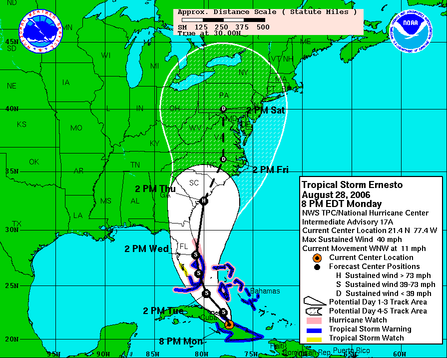
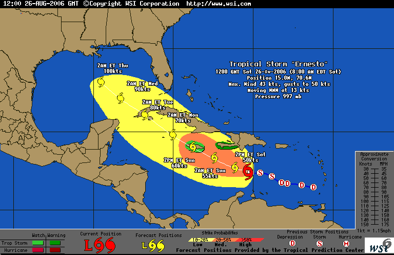
Thank you Haiti and Cuba for breaking Ernesto down to a very weak tropical storm. Winds are minimal and should be just a big rainmaker in Florida and primarily along the East Coast. The Carolinas will get rain and the possibility of some reformation so we wish them the best.

Tampa Bay will just see a very rainy day and a good dry run. Many stocked up on their hurricane supplies and reviewed their own personal storm plans

Meanwhile September may prove to be a very busy month starting with a tropical wave out in the Atlantic that forecasters expect to become a depression and eventually a named storm - Florence.

Something to look forward to next weekend!

Monday, August 28, 2006

Ernesto Roundup


We're feeling better here in the Tampa Bay area as the "cone of uncertainty" becomes some other community's bigger concern. All day today we've slowly edged towards the western fringe of the cone giving us reason to offer a collective sigh of relief. The forecasted path now seems to be more towards the eastern side of the state.

But things could change so we won't take our eye of the bouncing ball.

  • Ernesto did claim it's first life. Storm surge in Haiti on Sunday. Read about it here on an excellent blog written by Dr. Jeff Masters on the Weather Underground.

  • Internet rumor that Ernesto's shifting direction today caused the Weather Channel's hurricane expert, Dr. Steve Lyons , threw up his hands then and said "i don't have a clue?"

  • Tuesday is the 1-year anniversary of Katrina coming ashore in Louisiana.


  • Sunday, August 27, 2006

    Eastbound and Down.....but not Out!

    In the course of the day, the bullseye has gone from the first "R" in Clearwater to the last "R" (Click on map to enlarge).

    The entire state is in the "Cone of Uncertainty" but the predicted path does appear to be shifting to the East. Possibility that the storm may try to go straight up the middle of the state.

    As of 11pm, the land mass of Hispanioia (Haiti) has helped Ernesto to be downgraded to a Tropical Storm, but it's expected to strengthen overnight as it gets back out into the open warm waters of the Carribean.

    We'll see what tomorrow brings....

    Guess where we live?

    See the letter"R", that's hidden by the projected path in the word Clearwater on this map? (Click on the map to enlarge)

    That's us!

    Now, while I'm now concerned and making initial preparations for possible landfall on Thursday, the good news in my mind, is that I'd rather be in the bullseye today, rather than in 5 days.

    We'll be watching updates carefully!

    Saturday, August 26, 2006

    Max Mayfield Calling it Quits!


    "I'm tired," he said Friday.

    Meanwhile, Ernesto will keep us watching the Gulf heading into Labor Day!

    Thursday, August 24, 2006

    It's getting Busy....

    Debby - No Threat!

    Ernesto - Probably will be named within next 24 hours - Currently Tropical Depression #5.

    TD #5 satellite image

    One Year ago today, Tropical Storm Katrina formed in the Bahamas. Accuweather has a real good series which chronicles the historic and catastrophic event - "Katrina: One Year Later"

    14 years ago today, Hurricane Andrew struck South Florida. Here's the recap of that disaster.

    NASA Developing Hurricane Drone

    A demonstration flight of the unmanned Aerosonde Hurricane Boundary Layer Aerial System is scheduled today at the Naval Air Facility in Key West, Fla.

    Meanwhile, most forecasts have Debby headed up in to the Atlantic and threatening no one except the sea life and transatlantic ships.

    Tuesday, August 22, 2006

    Is Debby coming?


    From the New York Times:

    "Almost halfway through a hurricane season that had been predicted to be particularly awesome, the fourth potential hurricane of the year is gathering strength off the coast of West Africa, the National Hurricane Center said this morning. The three previous storms all fizzled out harmlessly at sea without reaching hurricane strength."

    The Tropical Storm is named Debby and formed this evening. Could be in Bermuda in a week, could just turn north into the Atlantic and not bother anyone.

    Stay tuned.

    Saturday, August 12, 2006

    My Hurricane Wind Insurance Premium Has Tripled!

    My wind insurance was transfered from the company, Citizens, which was called the "insurance of last resort" to another company which I imagine is the "insurance of TRULY last resort". Oh and by the way, it now costs THREE times what it did last year.

    And that's just the wind portion.

    I still have normal homeowners and flood, which gratefully did not go up more than a normal year over year increase. Most homeowners have hurricane insurance, albeit, paying through the nose. A fair number of commercial businesses had their insurance cancelled completely, hence, a special session of the Florida legislature may be called to deal with the issue

    Wednesday, August 09, 2006

    2006 Hurricane Forecast Lowered

    ....but really we're just getting started. Next Depression may be forming near the Lesser Antilles over next day or two. Lots of wind and rain but no formation at this point per Air Force Reconnaissance.

    Everyone is calm here in Florida at the moment focused on gas prices, insurance rates, and summer heat.

    Thursday, August 03, 2006

    TS Chris Weakens!

    But could re-form so we'll keep an eye on the news. CNN's headline is "Chris Falls Apart", however that may be a bit overstated.

    Meanwhile, quite the thunderstorm in Chicago last night. If the rains ends today, it's an Ernie Banks kind of day and we're playing two at Wrigley!

    Wednesday, August 02, 2006

    Still watching Chris from Chicago.....

    ....meanwhile, the temperature was a deadly 99 here in the Windy City Tuesday.

    Didn't like hearing one report this morning suggesting Chris's projected path through the straits of Florida is similar to the path as Katrina took last fall!

    Tuesday, August 01, 2006

    It's August, so let's start getting serious again!


    It was 2 years ago August that I started this blog in the form of emails to some of you. Charlie was threatening Florida and I was stuck at an airport in New England, at the end of a vacation, hoping my flight would leave and trying to get the latest weather on my cellphone's Internet browser.

    Since then the term "Hurricane" is much more on the tips of all Americans' tongues especially starting in August and especially in Florida and the Southeast. That's when the conditions in the Atlantic and Gulf of Mexico begin to be much more favorable for the development of storms. The warm water conditions will continue right through the end of the season in late November when they finally begin to cool down.

    It's no surprise that I wake up (on vacation again in Chicago - where the heat this week is worse than anything we experience in Florida) to hear about "Chris", the 3rd named storm of the 2006 season, which may become an issue in the US early next week.

    For the details from my favorite source of excellent Hurricane forecast information, click here.