Thursday, December 08, 2005
Epsilon Downgraded - The Season is Over!?
Meanwhile snow and cold weather hits the midwest and east. Our best wishes to YOU!
Friday, December 02, 2005
Epsilon becomes record 14th hurricane

We may not be done!
The latest that a hurricane formed in the Caribbean was Dec. 30, 1954
Wednesday, November 30, 2005
It's Over!
Today's the last "official" day of the 2005 Hurricane Season.
Tropical Storm Epsilon is still active in the Atlantic
I feel like I'm back at the frat house!
For those of you keeping track this year:
26 Named Storms. Previous Record - 21 (1933)
13 Hurricanes (unless Epsilon becomes a hurricane) Previous record - 12 (1969)7 Majors (Cat 3 or higher)
For all the tropical weather records set in 2005, click here
Wednesday, November 23, 2005
Cold Front Blows Through - More Damage than Wilma
Garbage cans, pool umbrellas, basketball hoops tip as gusts up to 40 miles an hour bring 40s and 50s overnight to Florida.
HAPPY THANKSGIVING!
HAPPY THANKSGIVING!
Sunday, November 20, 2005
Gamma Gone!
Gamma's maximum sustained winds dropped to 35 miles per hour and has been downgraded to a tropical depression. We have a few clouds but otherwise should be unaffected.
Friday, November 18, 2005
Gamma....Yup!
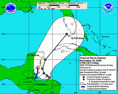
And incredibly, it may make landfall in South Florida following the track of Wilma!
Heading into Thanksgiving week, we are at the very top of the "cone of uncertainty tonight"
Tuesday, November 15, 2005
Gamma Ray?

This is the Greek letter Gamma
Tropical Depression #27....that's right, the year's 27th tropical system, is bouncing around south of Jamaica. May become a Tropical Storm, be named Gamma and would be the 24th named storm of this record breaking season. Potential to become a hurricane by week's end.
Not too concerned here but it gives the weathermen something to talk about and "keep an eye on".
Tuesday, November 08, 2005
We may be done!
Local forecasters say the current weather patterns should keep any late-season tropical developments away from the Florida penninsula between now and the official end of hurricane season on December 1st.
Meanwhile, I bought a relatively new circular saw for $5 at a garage sale last weekend so I'm prepared to cut more boards next season should need be.
There is really good and interesting on-going Southwest Florida coverage of Wilma at the Bonita News(paper's) website. Photos, webcams, even a daily podcast. I believe this is application is a glimpse of the future of newspaper industry. Check it out!
Thursday, October 27, 2005
I missed Wilma......Twice!
Not only did the Tampa Bay area escape Wilma, but I was supposed to be in Cancun last week for our company's annual convention. It was cancelled Monday, the day before our scheduled departure. Most of the early arrivals got out before the Cancun airport closed on Thursday. However, nine people waited too long and after a very tough week in shelters, took a 10-hour bus ride to Mexico City and flew back to the United States today.
The convention was scheduled for the Ritz-Carlton which suffered extensive damage and will be closed through at least the end of the year! Worst of all, Tom Cruise and Katie Holmes won't be able to be married there next month as planned.
Meanwhile, the Beta Storm is headed for Central America
The convention was scheduled for the Ritz-Carlton which suffered extensive damage and will be closed through at least the end of the year! Worst of all, Tom Cruise and Katie Holmes won't be able to be married there next month as planned.
Meanwhile, the Beta Storm is headed for Central America
Monday, October 24, 2005

The Waiting is Over!
St. Petersburg Times Online
Here in the Tampa Bay area, no power outages, no flooding, just some small tree twigs down. School was cancelled today as a precaution. Most employers asking workers to arrive later this morning. Emergency Operations Center never really went into high gear and will close this afternoon.
Storm should be through by lunchtime followed by cold weather (by Florida standards - 50s overnight) and sunshine.
Did you see that Tropical Storm Alpha formed over the weekend near Puerto Rico? Forecasted to track north into the Atlantic Ocean with no threat posed to the US mainland.
Sunday, October 23, 2005
Some Strong Wind & Rain in Tampa Bay - That's it!
Threat of a tornado through Monday afternoon, however it looks like we'll be spared from Wilma. Best of luck to South Florida who will take the brunt of the storm.
For a site with the best news from the Naples area, click here
Saturday, October 22, 2005

Friday, October 21, 2005


Thursday, October 20, 2005
SLOW then WHOA!

Wilma must have her feet out the bottom of Fred's car and has slowed down to the point where she will probably not affect Florida directly until later Saturday night or Sunday when that cold front (those of you up north will be feeling) deepens south across the Tennessee Valley and gives Wilma a big push to the Northeast.
Tropical storm-force winds extend outward up to 260 miles from the hurricane's center.
Wednesday, October 19, 2005
Uncertainty!

Max Mayfield, Director of the National Huricane Center says at 4:45pm this afternoon, that they have "lower confidence than normal" with their computer models. Florida still the likely landfall target but where is a question.
Gas lines beginning to form (especially at Sam's Club where $2.56/gallon is the lowest around). Batteries and water were selling swiftly tonight. I've got much of our supplies from last season still in the garage (plastic sheeting, duck tape, tarps, and a still unopened chain saw).
Meanwhile, our cancelled business trip to Cancun looks more and more like a great decision as the storm is bound to impact the Yucatan.
This could have been me:

Wilma the strongest Atlantic hurricane EVER!

.....based on pressure. Still uncertain where in Florida she goes later this week.
Monday, October 17, 2005
Hurricane WILMA becomes RECORD SETTING 21st named storm!

My trip to Cancun has been cancelled! (seriously)
More frequent updates to follow as the Tampa Bay area gears up for its first real serious threat this season!
The BEST expert forecast analysis can be found here
Monday, October 10, 2005
One More Storm Name Left to go!
After Wilma, according to NOAA's website: "In the event that more than 21 named tropical cyclones occur in the Atlantic basin in a season, additional storms will take names from the Greek alphabet: Alpha, Beta, Gamma, Delta, and so on."
Saturday, October 08, 2005
A Storm Named VINCE & Tampa Bay

After 10 years of baseball hell in Tampa Bay that compiled the worst record in modern new team history, the ownership headed by a man named "Vince" (Namoli), was passed to Stuart Sternberg and his group of baby-boomer partners (hey I'm one too! - baby boomer not investor)this past Thursday. This was a GREAT day in Tampa Bay!
My wife says wouldn't it be bizarre if the next storm, scheduled to be called "Vince" were to hit Tampa Bay!
Hurricane Vince formed on Sunday and won't get anywhere near Florida. It may actually affect Europe. So much for the Vince theory!
Saturday, October 01, 2005

Monday, September 19, 2005
Rita to stay south of us!?

So far so good for us in Tampa Bay. But I worry when they say the storm is NOT headed our way!
Saturday, September 17, 2005
Marga-RITA-ville!
The eighteenth tropical depression of the season also formed late Saturday night. As of 11:00 P.M. EDT, Tropical Depression Eighteen was located near 22.0 North and 69.7 West or about 95 miles east-northeast of Grand Turk Island. Movement of Tropical Depression Eighteen was moving toward the west-northwest at 10 mph with maximum sustained winds of 30 mph. The estimated minimum central pressure is 1009 millibars or 29.80 inches.
Tropical Depression Eighteen will strengthen over the next 48-72 hours as it continues moving toward the west-northwest. Once this system becomes a tropical storm, it will be named Rita. Heavy rains and gusty winds will move through the Bahamas over the next couple of days and the track of this system will take it very close to the southern tip of Florida by Tuesday.
Tropical Storm Warnings have been posted for the Turks and Caicos, as well as, the central and southeastern Bahamas. Hurricane Watches have been issued for the northwest Bahamas. Watches and warnings may need to be issued as early as Sunday for south Florida.
Friday, September 09, 2005
Katrina Photos & More
Survivor Photos
NOAA Satellite Photos
Police made their storm misery worse: Unbelievable story
Complete Katrina Resource Page("wiki")
Listen to local radio in New Orleans
NOAA Satellite Photos
Police made their storm misery worse: Unbelievable story
Complete Katrina Resource Page("wiki")
Listen to local radio in New Orleans
Thursday, September 08, 2005
Wednesday, September 07, 2005
The Ophelia I remember - Can you name the movie?

The Tropical Storm Ophelia is supposed to hang off the East coast of Florida the rest of the week. Could go out to sea, cross Florida into the Gulf or head to the Carolinas.
We're keeping an eye on Opheila!!
By the way, here's a more conventional definition of Ophelia
Tuesday, September 06, 2005
Ophelia could be named in next 24 hours
The disturbance off the East coast of Florida, now Tropical Depression 16, is potentially becoming a tropical storm. For the rest of this week, Miami to Jacksonville and even Orlando and Tampa Bay could be affected by at least heavy rain, potentially more!
Stay tuned!
Stay tuned!
Monday, September 05, 2005
Maria's now a Hurricane & there is lots of activity in the Atlantic
Forecasters here are saying to keep an eye on the disturbance between Miami and the Bahamas. While possible to develop, they are hoping it will just throw a lot of rain on to the Florida pennisula.
As we roll into the height of the Hurricane season there are several other waves and activity out in the Atlantic to keep a heads up on. Click here to see the Satellite Image from NOAA
As we roll into the height of the Hurricane season there are several other waves and activity out in the Atlantic to keep a heads up on. Click here to see the Satellite Image from NOAA
Saturday, September 03, 2005
Tropical Storm Maria now churning in the Atlantic
Tropical Storm Maria is located about 1125 miles southeast of Bermuda. Maria could strengthen into a hurricane by Sunday. Maria will continue on a northwest track through the weekend.
Friday, September 02, 2005
Frustrated and tired Mayor of New Orleans Explodes
Thursday, September 01, 2005
Live News Updates from New Orleans:
Newspaper: http://www.nola.com/hurricane/katrina/
TV Website with regualr updates: http://www.wwltv.com/
Live video on the web: http://abc26.trb.com/news/wgno-hurricane-livestream,0,6270996.htmlstory?coll=wgno-home-1
Meanwhile:
Fats Domino found alive in New Orleans
Washington Post Photos
TV Website with regualr updates: http://www.wwltv.com/
Live video on the web: http://abc26.trb.com/news/wgno-hurricane-livestream,0,6270996.htmlstory?coll=wgno-home-1
Meanwhile:
Fats Domino found alive in New Orleans
Washington Post Photos
Tropical Storm Lee has already come and gone
Lee has gone from Tropical Storm to Depression as it heads north into colder Atlantic water.
Meanwhile, while all eyes are on Katrina's catistrophic aftermath, a couple more tropical waves are developing in the Atlantic.
Meanwhile, while all eyes are on Katrina's catistrophic aftermath, a couple more tropical waves are developing in the Atlantic.
Wednesday, August 31, 2005
New Orleans Times-Picayune Breaking News Blog
Monday, August 29, 2005
Saturday, August 27, 2005
Weather Channel's Storm Chasers are blogging
Friday, August 26, 2005
Still Sunny Here in Tampa Bay
More clouds, rain and wind yesterday. Just a nice strong breeze today....so far.
Looks like the Panhandle is going to get it again. See my post from July 23rd (below)
Looks like the Panhandle is going to get it again. See my post from July 23rd (below)
Houston, we have a problem!

The MTV mascot Moonman lies on its back after being removed from the roof of the official MTV hotel, the Doubletree Surfcomber, in preparation for Tropical Storm Katrina before it made landfall in Miami Beach, Thursday, Aug. 25, 2005.
The MTV Video Music Awards show is in Miami Sunday night. The city is hosting celebrities and partygoers in town for the Awards. MTV called off its pre-awards festivities Thursday and Friday.
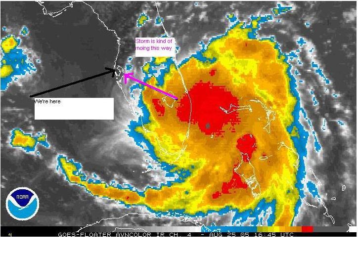
Thursday, August 25, 2005
We'll be making (Katrina & the) waves this weekend!
She's officially now a Hurricane

Should be a very rainy and somewhat gusty weekend in Tampa Bay starting Friday even though the eye of the storm may slide south of us.
Stay tuned!
Should be a very rainy and somewhat gusty weekend in Tampa Bay starting Friday even though the eye of the storm may slide south of us.
Stay tuned!
Wednesday, August 24, 2005
Katrina has been here before!
This is Katrina VI
Previous Katrinas:
1967
1971
1975
November 1981
October 1999
Here we just expect a lot of rain this weekend and some gusts depending where it crosses the state.
Previous Katrinas:
1967
1971
1975
November 1981
October 1999
Here we just expect a lot of rain this weekend and some gusts depending where it crosses the state.
Number 11 Expected to hit Florida this Weekend!
Tropical Storm Katrina should be named later today and cross the state Friday.
Let’s hope she doesn’t make many WAVES! I'd rather be walking on sunshine!
Let’s hope she doesn’t make many WAVES! I'd rather be walking on sunshine!
Tuesday, August 23, 2005
Ten Storms Down.....?? to go......
Adios Jose. A non-event for the US. We're still here watching the tropics as the real season gets ready to commence....LOL
Saturday, August 13, 2005
Tuesday, July 26, 2005
Sunday, July 24, 2005
Who would have thought 7 named storms before the end of July?
Tropical Depression Seven becomes Tropical Storm Gert in the Bay of Campeche Sunday morning and Tropical Storm Franklin is Moving Toward Bermuda
Gert will affect the eastern Mexican coast near Tampico Sunday evening.
Time to listen to Jimmy Buffett's Changes in Lattitudes -- Changes in Attitudes CD with the track "Tampico Trauma"
Gert will affect the eastern Mexican coast near Tampico Sunday evening.
Time to listen to Jimmy Buffett's Changes in Lattitudes -- Changes in Attitudes CD with the track "Tampico Trauma"
Saturday, July 23, 2005
Which "expert" has been right so far this season?

Joe Bastardi of Accuweather predicted the "Central Gulf Coast" would be the hot spot this season.
Read the article
Read Joe's bio
Friday, July 22, 2005
Storm # 6 is born! Franklin is his name
Click on the headline above for the tracking map.
Looks like from the Bahamas he's going on an Atlantic Ocean cruise.
We certainly hope so!
Looks like from the Bahamas he's going on an Atlantic Ocean cruise.
We certainly hope so!
Saturday, July 16, 2005
Friday, July 15, 2005
Emily a Category 4 Yet Again
Strengthening, weakening, and strengthening again; Emily is once again a Category 4 hurricane.
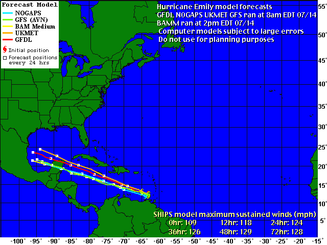
Thursday, July 14, 2005
EMILY Becomes a DANGEROUS category 3 Hurricane!
AT 5 PM AST...2100Z...THE GOVERNMENT OF JAMAICA HAS ISSUED A
HURRICANE WATCH FOR JAMAICA.
Could be a Category 4 by the time it reaches Jamaica!
State of Florida appears to be out of play on this one, but keep your eye on the west coast of Africa where these things are incubating!
Wednesday, July 13, 2005
Emily is Now a Hurricane!
Looks like she'll stay south of the Florida Pennisula. Mexico and South Texas appear to be in the projected path's "cone of uncertainty".
Meanwhile.... Do you know where do the Alligators go during a storm?
Meanwhile.... Do you know where do the Alligators go during a storm?
Sunday, July 10, 2005
The next one may already be brewing...
From Accuweather Sunday Night:
"What could very well become the season's next tropical cyclone is in the Atlantic with a developing cloud mass at 11 north and 40 west. With water warm and shear low, next week at this time yet another tropical threat may face the coastal United States. "
Could it be deja vu all over again!
Sun came out Sunday afternoon. All clear here. Best to those in the southeast still being affected by Dennis!!
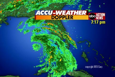
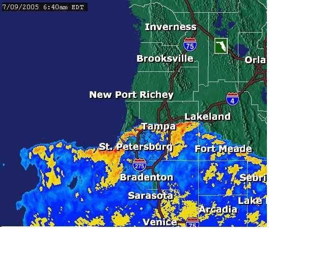
Rain & Wind just about done here....
 The storm pounds into the panhandle and lucky for us we just have a few leaves down in our front yard (We are located where the green on this radar shot is ending on the west side of the state).
Some minor street flooding in the low lying spots in the Tampa Bay area due to high tide and storm surge this morning but we were unaffected.
Saturday, July 09, 2005

Dennis Sideswipe!
Fairly calm since the last post. Occasional gusts but nothing like last season. Looks like the tropical storm force winds didn't quite make it this far from the storm center
Actually went out and ran some errands. You can see we still have a lot of rain over the area and the back side of the storm tonight and tomorrow. Best of luck to the Florida Panhandle and southern Alabama, Mississippi & Louisian!
Some Strong Weather Moving Through our Area Right Now
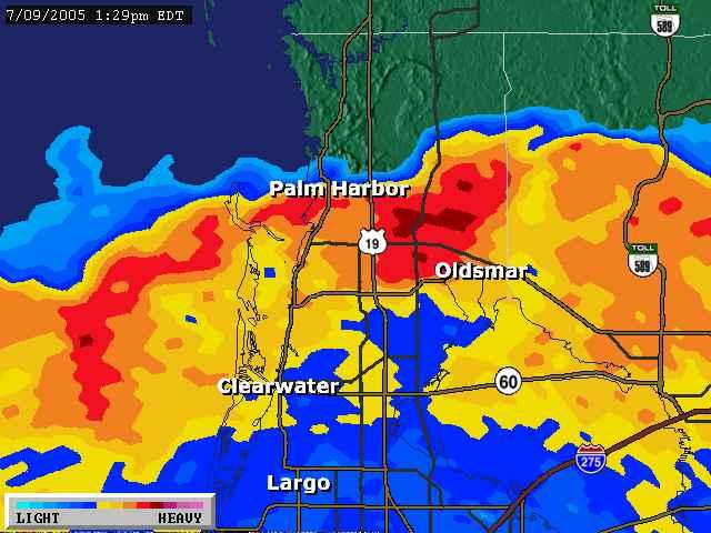
Small tornado hit one beach area south of us this morning. At this moment a strong band of weather is passing over us. Tornado Warning in effect until 2pm EST for our county. Heavy rain and wind visible from our house.
2800 people in our county without power currently.
We're okay but expect more fast moving heavy bands of weather through tomorrow.
Click here to see the size of Dennis!
7am Saturday - Dennis's outer bands of rain and wind begin!
A rainy day in Tampa Bay!
As I post this the rain has just begun. The storm will pass to our west. When it gets to 27.96 lattitude, we are in the clear for an unexpected and unlikely sudden right turn. Currently it's at 23.9.
Meanwhile, I think we'll stay inside today!
Thursday, July 07, 2005
Now I'm getting ANGRY!

Tropical Storm Cindy created tornados have caused an estimated $10-40 million worth of damage to our favorite NASCAR race track, Atlanta Motor Speedway .
The General Manager is an old friend of ours and I sure feel sorry for what he found this morning.
Meanwhile, we're not sure where Dennis is headed. The "cone of uncertainty" keeps wobbling to include or exclude our area. We'll know more late Friday after the storm passes Cuba. We'll gas up the vehicles tomorrow and prepare for at best a rainy somewhat windy weekend. At worst.....
He's headed to the Gulf of Mexico

The west coast of Florida is slowly moving to the outer edge of the "cone of uncertainty" as Dennis' future path computer models point towards the Florida panhandle.
The last named Hurricane this early in the season was Bertha in July 1996 that hit the Wilmington, NC area. 5000 homes were damaaged at a damage cost estimated at $270 million. Bertha was responsible for eight deaths.
Wednesday, July 06, 2005
Just a signal of what's to come......or getting them out of the way early?
Recorded Hurricane history goes back to 1851 and this is the earliest 4 named storms have developed this early in the season!
Overheard yesterday: "4 Down 11 to go! Maybe we're just getting them out of the way early this year"
Also overheard: "We had 4 storms hit the state last year. They're still coming in fours"
Overheard yesterday: "4 Down 11 to go! Maybe we're just getting them out of the way early this year"
Also overheard: "We had 4 storms hit the state last year. They're still coming in fours"
Tuesday, July 05, 2005
2 Hurricanes Happening This Week!
As of 11 a.m. today, Tropical Storm Cindy is moving toward the north at 14 mph and a gradual turn toward the north-northeast is expected during the next 24 hours. On this track, the center will be nearing the North Central Gulf Coast tonight or early Wednesday. Maximum sustained winds are near 50 mph. A Tropical Storm warning is now in effect from Intercoastal City, La. eastward to Destin, Fla.
Tropical Storm Dennis is centered about 355 miles south of San Juan, Puerto Rico and is moving west-northwest at 18 mph. It has top sustained winds of 40 mph and is on track to reach Haiti on Wednesday.
We're much more interested in Dennis which is currently projected to sweep up the eastern end of the Gulf of Mexico perhaps affecting us along Florida's West Coast!
Humor to follow!
Sunday, June 26, 2005
Hurricane fears fade fast in Florida
Click on the link above to read about Florida Tourism's BIG bounceback!
Sunday, June 12, 2005
One Down, 14 to Go!
Brett is next! See the list of this year's storms at the link to the right.
We just got a bunch of rain which looks like it's headed next to the midwest.
Anymore, it seems we all feel the effects of these storms!
We just got a bunch of rain which looks like it's headed next to the midwest.
Anymore, it seems we all feel the effects of these storms!
Thursday, June 09, 2005
Got a generator?
North Carolina-based Lowe's reports selling 25,000 generators in its 71 Florida stores since June 1. Atlanta's Home Depot called sales at its 128 Florida stores "very brisk," in part because it has discounted its generators - and everything else that qualifies for the state exemption. Through June 12th Floridians don't pay sales tax on certain hurricane prep items.
Click here for the elegible TAX-FREE ITEMS
Click here for the elegible TAX-FREE ITEMS
Tropical Storm Arlene is born!
Family & Friends: We'll keep you up to date this season on the popular new Florida pastime: "As the Wind Blows".
Leave a comment if you care, come visit us this season if you dare!
---------------------------------------------------------------------------------
PENSACOLA - Tropical Storm Arlene developed Thursday in the northwest Caribbean Sea, edging closer to western Cuba as the Atlantic hurricane season's first named storm. Gulf Coast residents, including those in storm-battered Florida, were warned to beware.
Arlene had maximum sustained winds of 40 mph after strengthening from a tropical depression that formed Wednesday, the National Hurricane Center in Miami said. Tropical storms have top sustained winds of 39 mph to 74 mph.
At 11 a.m. EDT, the storm's center was about 165 miles south-southeast of the western tip of Cuba. It was moving north at about 8 mph, and this motion could bring the storm's center near western Cuba as early as Thursday night, forecasters said.
The large storm's winds and rain extended 150 miles to the north and east from its poorly organized center, meaning parts of the Florida Keys could start getting rain Thursday, forecasters said.
Arlene was expected to enter the Gulf of Mexico by Friday, and residents from Florida to Louisiana were told to keep an eye on the tropical storm.
Subscribe to:
Posts (Atom)