When I went to bed last night, the "Invest" in the Gulf had a 20% chance of forming. This morning I was awoken by Topical Storm Warnings on my phone. This appears to be a "Low-End" Tropical Storm that will dump another 2 inches or so where we live and up to 4 inches south of Tampa Bay.
Some power outages including 1200 customers near (not so) Sun City.
There are some gusts and tornado watches/warnings for the Sarasota/Bradenton area to our south. Wind is strong on the Sunshine Skyway Bridge between St. Petersburg and that area over the mouth of Tampa Bay and traffic is stopped due to the gusts:
From the radar, it appears that south central Florida will get the brunt of this rain event.
Monday, July 31, 2017
Tuesday, July 18, 2017
Sunday, June 18, 2017
Saturday, March 18, 2017
National Hurricane Center rolls out new look for 'cone of uncertainty'
Changes for the upcoming Hurricane Season (which starts in just over 60 days):
http://www.tampabay.com/news/weather/hurricanes/national-hurricane-center-rolls-out-new-look-for-cone-of-uncertainty/2316986?
Thursday, December 01, 2016
The Season & the Drought Are Over
While I had more to watch & post about this summer and even had some minor impact from this season's storms, but all-in-all, it was much to do about nothing on the West coast of Florida. Yes, we had a lot of rainfall that impacted some low lying areas around Tampa Bay. But, these areas tend to flood on any heavy rain. I'm sorry for those impacted by that, but they are used to it and I don't believe there was much serious damage to many homes or property
Yes, the headline is that after 10 years (Wilma in 2005), we finally had a hurricane make landfall in the state of Florida (Hermine)
We sat through a full day of rain from Hermine on September 2nd in Darlington South Carolina after it passed by the Tampa Bay area and made landfall in the Big Bend area of Florida and continued Northeast. At home we received well over 5 inches of rain that day.
Matthew didn't throw anything but some lighter rain at us over here, which was the last significant rain we received the week of October 3rd. While no wildfires (like in the Carolinas and Tennessee), we haven't seen rain in nearly 2 months here in Tampa Bay.
Here's one recap of the 2016 season: http://www.miamiherald.com/news/weather/hurricane/article117789853.html
Yes, the headline is that after 10 years (Wilma in 2005), we finally had a hurricane make landfall in the state of Florida (Hermine)
We sat through a full day of rain from Hermine on September 2nd in Darlington South Carolina after it passed by the Tampa Bay area and made landfall in the Big Bend area of Florida and continued Northeast. At home we received well over 5 inches of rain that day.
Matthew didn't throw anything but some lighter rain at us over here, which was the last significant rain we received the week of October 3rd. While no wildfires (like in the Carolinas and Tennessee), we haven't seen rain in nearly 2 months here in Tampa Bay.
Here's one recap of the 2016 season: http://www.miamiherald.com/news/weather/hurricane/article117789853.html
Tuesday, October 11, 2016
Why Did Matthew Wobble?
Excellent recap from The Weather Channel & some awesome pictures from throughout Matthew's path: https://weather.com/storms/hurricane/news/hurricane-matthew-florida-could-have-been-worse
Reported Matthew Impact on Tampa Bay So Far....
According to the Tampa Bay Business Journal, there have been 80 regional insurance claims thus far, the most of which were in Sarasota County. Here's the article.
Sunday, October 09, 2016
Matthew Aftermath
There is plenty of coverage of Matthew on the Internet. Unlike when I started this blog 12 years ago, it's easy to access the news, both in terms of live video & blog feeds from those inside the path via Twitter, Facebook and other social media, not to mention a simple Google search. Back in the day I might have included links to coverage I had found on the web, but it really seems necessary today.
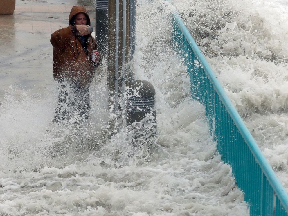
In 2004 when Charley, Jeanne & the others hit, 64 in 100 people had cellphones. Today 112 in 100 have one, most of which are smart phones with cameras and easy connection to connect to the Internet to share their experiences.
In summation from the West Coast of Florida, where we had nothing more than a little rain and some slightly-more-than-normal wind, we have nothing to complain about and feel lucky we aren't going through what our fellow Floridians (as well as Carolinians) are going to have to go through to clean up and restore.
My only concern going forward is that since the majority of the residents here in Florida were NOT affected (or very slightly affected) and the coverage during the impact of the storm "seemed" alot less than expected (where were those 9 foot storm surges in Florida?), that we will continue to be complacent should another storm take a more powerful head-on impact into the state.
I give the governors of each state affected a lot of credit for taking the most serious warning approach to their messaging, even if it seems that the impact was not has bad as advertised. Another 30-50 miles closer to shore or a left turn to make a Florida landfall, and perhaps it would have been as bad or worse than warned.
And of course, thank you the first responders and condolences to anyone who lost life or significant property!
In 2004 when Charley, Jeanne & the others hit, 64 in 100 people had cellphones. Today 112 in 100 have one, most of which are smart phones with cameras and easy connection to connect to the Internet to share their experiences.
Brian Johns is hit by a wave as he tries to video the effects of Hurricane Matthew, Oct. 7, 2016, in Daytona Beach, Fla.
My only concern going forward is that since the majority of the residents here in Florida were NOT affected (or very slightly affected) and the coverage during the impact of the storm "seemed" alot less than expected (where were those 9 foot storm surges in Florida?), that we will continue to be complacent should another storm take a more powerful head-on impact into the state.
I give the governors of each state affected a lot of credit for taking the most serious warning approach to their messaging, even if it seems that the impact was not has bad as advertised. Another 30-50 miles closer to shore or a left turn to make a Florida landfall, and perhaps it would have been as bad or worse than warned.
And of course, thank you the first responders and condolences to anyone who lost life or significant property!
Friday, October 07, 2016
West Coast of Florida OK
So far we really haven't experienced anything more than a few minor wind gusts. Since we are 10 miles from the Gulf of Mexico, we're pretty insulated from Matthew which of course is a terrible concern for the east coast of Florida.
We spent most of yesterday watching The Weather Channel, CNN & Twitter to follow Matthew's north/northwestern approach to the peninsula.
Here's what radar looked like last night, but the rain was so light we only received less than a quarter of an inch overnight.
We spent most of yesterday watching The Weather Channel, CNN & Twitter to follow Matthew's north/northwestern approach to the peninsula.
Here's what radar looked like last night, but the rain was so light we only received less than a quarter of an inch overnight.
Subscribe to:
Posts (Atom)