Thursday, August 17, 2017

Harvey, Irma and Jose?

From the Patch.  Very professional story:
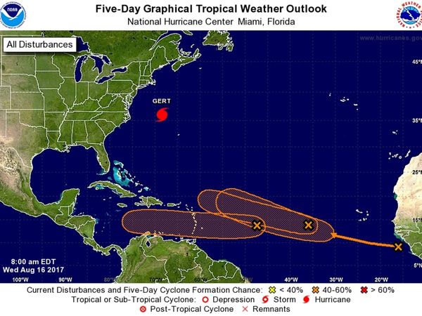
TAMPA, FL — Forecasters at the National Hurricane Center were busy Wednesday morning monitoring four separate storm systems in the Atlantic Ocean. While Hurricane Gert is making the most waves, three areas of disturbed weather are showing stronger signs for the potential to develop into the Atlantic hurricane season’s next named storms.
Hurricane Gert was located about 330 miles northwest of Bermuda as of the center’s Wednesday morning update. The Category 1 storm was packing maximum sustained winds of 90 mph while moving northeast at 21 mph. Gert is following a projected path that will take her into the open Atlantic over the next few days before encounters with cooler waters are expected to cause her to downgrade back to tropical storm status.


The three disturbances under watch were all located in the southern Atlantic Ocean as of Wednesday morning. The first system is an area of low pressure that was located about 900 miles east of the Lesser Antilles as of the hurricane center’s 8 a.m. Aug. 16 Tropical Weather Outlook report. The storm was moving westward at an estimated 15 mph. It’s expected to cross into the Caribbean Sea by Friday. “Upper-level winds are forecast to become a little more conducive for development during the next several days,” the center warned Wednesday morning. The system has been given a 30 percent chance of developing more over the next 48 hours. Chances rise to 40 percent over the next five days.
The second disturbance under watch was located a few hundred miles west of the Cabo Verde Islands Wednesday morning. Forecasters expect the low pressure system to move west-northwest at 15 to 20 mph over the next few days. Gradual development is possible as the workweek continues, but forecasters say the storm may encounter less conducive conditions over the weekend. As of Wednesday, the system had been given a 30 percent chance of developing more over the next 48 hours. Those chances rise to 40 percent over the next five days.


A tropical wave near the coast of Africa is also under watch. The center says conditions do appear conducive for the system’s gradual development as it moves westward at an estimated 15 mph over the next few days. That storm has been given no chance of forming more over the next 48 hours. The chances, however, rise to 40 percent over the next five days.
Should the systems develop enough to earn names, the next three up are Harvey, Irma and Jose.

Back in May, NOAA forecast a 45 percent chance of an above-normal season. Last week, that number rose to a 60 percent chance.


Forecasters call the period between mid-August and mid-October the “season within the season.” This eight-week period “is often the most active and dangerous time for tropical cyclone activity,” according to NOAA.
The peak period is historically responsible for major spikes in tropical weather activity, NOAA said. In fact, it accounts for roughly 78 percent of all tropical storm days on record. It is also the period when 87 percent of the category 1 and 2 hurricane days on record occurred. In addition, this period is responsible for “a whopping 96 percent of the major (category 3, 4 and 5) hurricane days.”

The Atlantic hurricane season runs from June 1 to Nov. 30 each year. Average seasons produce about 12 named storms, of which six become hurricanes. Three of the hurricanes are generally deemed major.

Monday, July 31, 2017

Emily Unexpectedly

When I went to bed last night, the "Invest" in the Gulf had a 20% chance of forming.   This morning I was awoken by Topical Storm Warnings on my phone.  This appears to be a "Low-End" Tropical Storm that will dump another 2 inches or so where we live and up to 4 inches south of Tampa Bay.

Some power outages including 1200 customers near (not so) Sun City.

There are some gusts and tornado watches/warnings for the Sarasota/Bradenton area to our south. Wind is strong on the Sunshine Skyway Bridge between St. Petersburg and that area over the mouth of Tampa Bay and traffic is stopped due to the gusts:


From the radar, it appears that south central Florida will get the brunt of this rain event.


Saturday, March 18, 2017

National Hurricane Center rolls out new look for 'cone of uncertainty'

Changes for the upcoming Hurricane Season (which starts in just over 60 days):

http://www.tampabay.com/news/weather/hurricanes/national-hurricane-center-rolls-out-new-look-for-cone-of-uncertainty/2316986?

Thursday, December 01, 2016

The Season & the Drought Are Over

While I had more to watch & post about this summer and even had some minor impact from this season's storms, but all-in-all, it was much to do about nothing on the West coast of Florida.  Yes, we had a lot of rainfall that impacted some low lying areas around Tampa Bay.  But, these areas tend to flood on any heavy rain.   I'm sorry for those impacted by that, but they are used to it and I don't believe there was much serious damage to many homes or property

Yes, the headline is that after 10 years (Wilma in 2005), we finally had a hurricane make landfall in the state of Florida (Hermine)

We sat through a full day of rain from Hermine on September 2nd in Darlington South Carolina after it passed by the Tampa Bay area and made landfall in the Big Bend area of Florida and continued Northeast.  At home we received well over 5 inches of rain that day.


Matthew didn't throw anything but some lighter rain at us over here, which was the last significant rain we received the week of October 3rd.   While no wildfires (like in the Carolinas and Tennessee), we haven't seen rain in nearly 2 months here in Tampa Bay.

Here's one recap of the 2016 season:   http://www.miamiherald.com/news/weather/hurricane/article117789853.html

Tuesday, October 11, 2016

Sunday, October 09, 2016

Matthew Aftermath

There is plenty of coverage of Matthew on the Internet.  Unlike when I started this blog 12 years ago, it's easy to access the news, both in terms of live video & blog feeds from those inside the path via Twitter, Facebook and other social media, not to mention a simple Google search.   Back in the day I might have included links to coverage I had found on the web, but it really seems necessary today.


In 2004 when Charley, Jeanne & the others hit, 64 in 100 people had cellphones.   Today 112 in 100 have one, most of which are smart phones with cameras and easy connection to connect to the Internet to share their experiences.


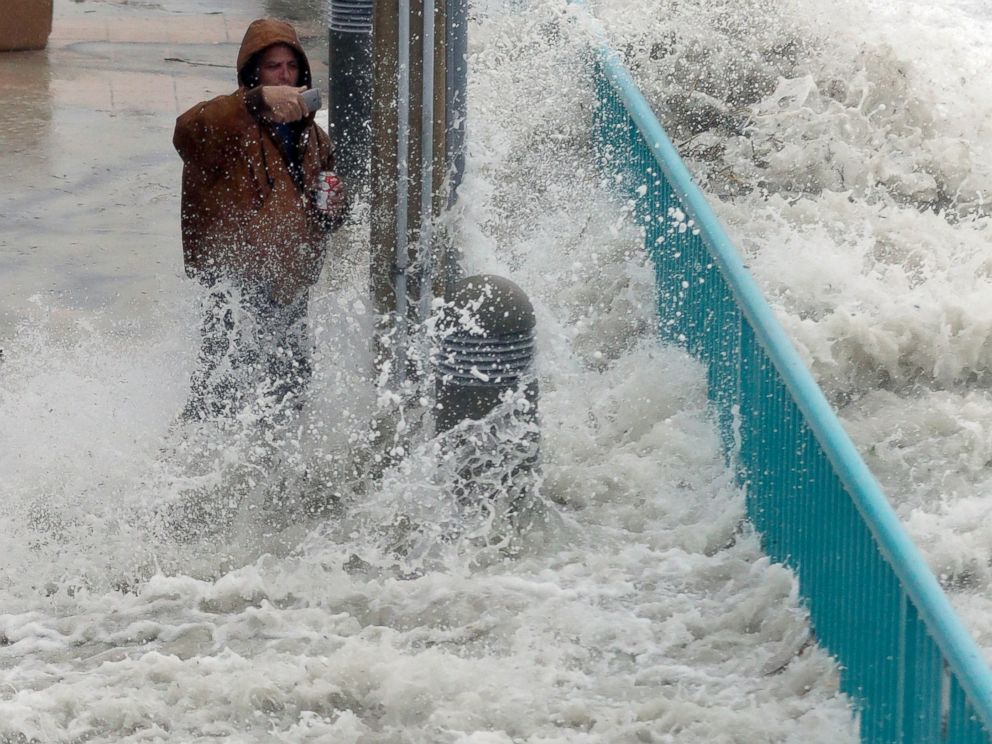
Brian Johns is hit by a wave as he tries to video the effects of Hurricane Matthew, Oct. 7, 2016, in Daytona Beach, Fla.


In summation from the West Coast of Florida, where we had nothing more than a little rain and some slightly-more-than-normal wind, we have nothing to complain about and feel lucky we aren't going through what our fellow Floridians (as well as Carolinians) are going to have to go through to clean up and restore.


My only concern going forward is that since the majority of the residents here in Florida were NOT affected (or very slightly affected) and the coverage during the impact of the storm "seemed" alot less than expected (where were those 9 foot storm surges in Florida?), that we will continue to be complacent should another storm take a more powerful head-on impact into the state.

I give the governors of each state affected a lot of credit for taking the most serious warning approach to their messaging, even if it seems that the impact was not has bad as advertised.  Another 30-50 miles closer to shore or a left turn to make a Florida landfall, and perhaps it would have been as bad or worse than warned.

And of course, thank you the first responders and condolences to anyone who lost life or significant property!