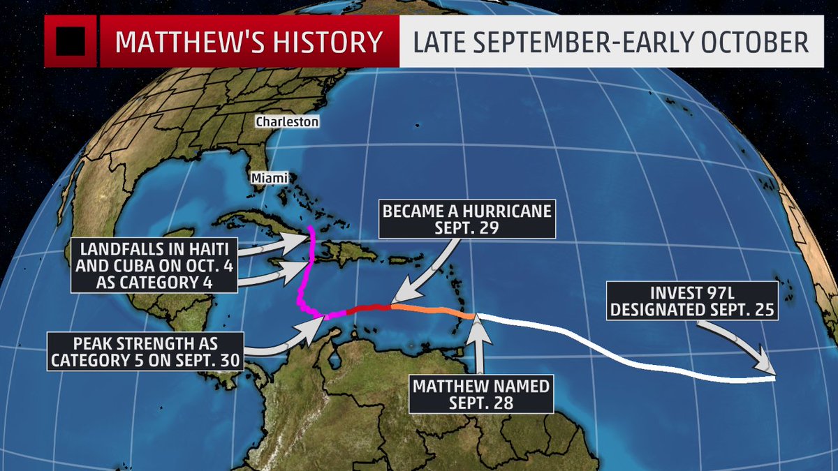
So far we really haven't experienced anything more than a few minor wind gusts. Since we are 10 miles from the Gulf of Mexico, we're pretty insulated from Matthew which of course is a terrible concern for the east coast of Florida.
We spent most of yesterday watching The Weather Channel, CNN & Twitter to follow Matthew's north/northwestern approach to the peninsula.
Here's what radar looked like last night, but the rain was so light we only received less than a quarter of an inch overnight.
Friday, October 07, 2016
Wednesday, October 05, 2016
Matthew Already A Record Setter
Hurricane Matthew has already set records:
- The longest-lived Category 4-5 hurricane in the eastern Caribbean on record
- A Category 4-5 hurricane for 102 hours, which is the longest that a hurricane has maintained Category 4-5 strength on record during October in the Atlantic basin.
- The longest-lived major hurricane since Hurricane Ivan (2004).
- Generated the most ACE (accumulated cyclone energy <length+intensity>) of any hurricane in the eastern Caribbean on record
- No hurricanes on record have made landfall north of Miami along the east coast of Florida in October and no major hurricanes have made landfall since Wilma in 2005. Each of these records has the potential to be broken in the next few days.
West Coast of Florida Safe from Matthew?
Here in the Tampa Bay area, we've been watching the foretasted track of Hurricane Matthew more intently over the weekend and into this week. At first it appeared that the entire peninsula would be spared but as the cone of uncertainty has shifted more westward and the storm continues to intensify, we've paid even more attention.
That said, we seem to be in a better position to only receive some additional rain and wind but nothing that should be damaging. On the west side of the storm potentially even could suck some of the moisture out of the air according to local meteorologists.
We feel bad for Haiti and what the Bahamas may endure today and are concerned about the impact to coastal Carolina later in the week.
I continue to have the Weather Channel on and keep an eye on some of the weather Tweeps I follow.
Monday, October 03, 2016
Florida's Back In Play
Interesting to note that 7 of 9 major hurricanes making U.S. landfall in October since 1900, have done so in Florida.
Saturday, October 01, 2016
Matthew is intense!
Here in Florida we are watching Hurricane Matthew even more intently. Matthew just about doubled its wind-speed in 24 hours. It intensified by 80mph. Only Wilma in 2004 & Felix in 2007 had stronger 24 hour intensification per Philip Klotzbach The east coast of Florida is still in the cone of uncertainty and this storm is currently Category 4 (had been a "5" briefly overnight), the strongest since Felix!
Thursday, September 29, 2016
Matthew Forms!
Good Morning from Florida where attention is beginning to turn to Matthew, the strongest named storm in the eastern Caribbean since 2007!
Monday, September 26, 2016
12 Years Ago Jeanne made Florida Landfall
That crazy year of 2004 continued.....
Click for animation: https://twitter.com/weatherchannel/status/780410540799557633/video/1
Tuesday, September 13, 2016
Julia Forms Over Land
Our CBS TV affiliate says it's been 30 years since a named storm has formed while on land. Tropical Storm Julia did just that this evening near Jacksonville, Florida.
Friday, September 02, 2016
The streak is over!
After nearly 11 years without a hurricane making landfall in Florida, Hermine is about to break the streak.
While Tampa Bay has received a lot of rain, I am not there to enjoy. We are in South Carolina and will see what's left of
Hermine on Friday (9/2/16)
My neighbor lowered the pool water level for me. From:
The rain will move out this evening as the storm makes landfall up near Tallahassee. Tomorrow is forecast to be a complete rainout here in the Carolinas.
Wednesday, July 06, 2016
Now 15 Named Storms Predicted
Colorado State University's Dr. Phil Klotzbach & team have now increased their prediction of named storms in the Atlantic season from 13 on April 14th to 14 on June 1st to 15 on July 1st. This makes the 2016 season predicted to be an average season, but the most active since 2012
Here's a nice summary from Carribean360. And the official forecast from CSU
Subscribe to:
Posts (Atom)